Pillboxes were not the only type of fortifications built at Mellieha in the years before the outbreak of the Second World War. There were other minor military structures but the most important fortification to be built in Mellieha, and the last fort to be built in Malta by the British, was Fort Campbell.
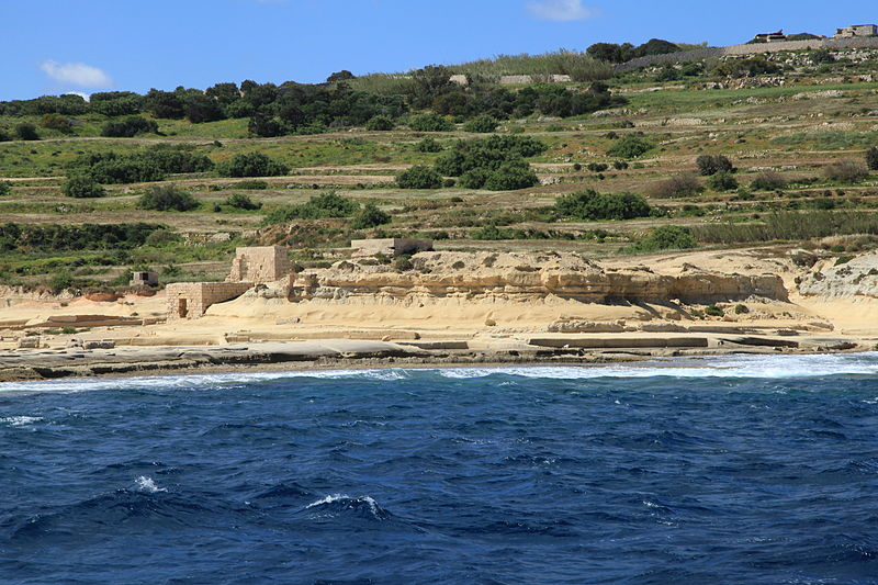
The main scope for the building of Fort Campbell was to protect the approaches for Mellieha and St. Paul’s Bays. That is because there were no defences to protect these two approaches and so, a decision was taken to build a new fort on Il-Blata, at the end of the Selmun promontory. Governor Bonham-Carter, while on tour around the Island, visited the site where Fort Campbell was to be built. Although the building of Fort Campbell is reported to have begun in 1937 it seems that till 1 December 1937 no work had been started on this site. 1 Probably the work started at the very end of the same year.
The new fort was designed to mount two 6-inch guns.2 Bonham-Carter insisted that the work on this fort had to be hurried up,3 because after the Munich Crises of September 1938 4 it was seen that a war was coming, and all the fortifications being built had to be finished as quickly as possible.5 It is important to note that the design of this fort reflected the need to contend with a new threat in the form of aerial bombardment. So protection against air attack had become a vital consideration. 6
The main characteristic of the British fortifications of the late 19th century was the thick ramparts and ditches. But by this time these characteristics were abandoned in favour of thin walls. Therefore, Fort Campbell was built with a thin wall to resemble the field walls of the surrounding countryside, while the plan was broken up by an irregular trace designed to imitate the pattern of the adjoining terraced fields. Perimeter defence was provided by a number of machine-gun posts placed at irregular intervals and in other places there were few rifle loopholes.
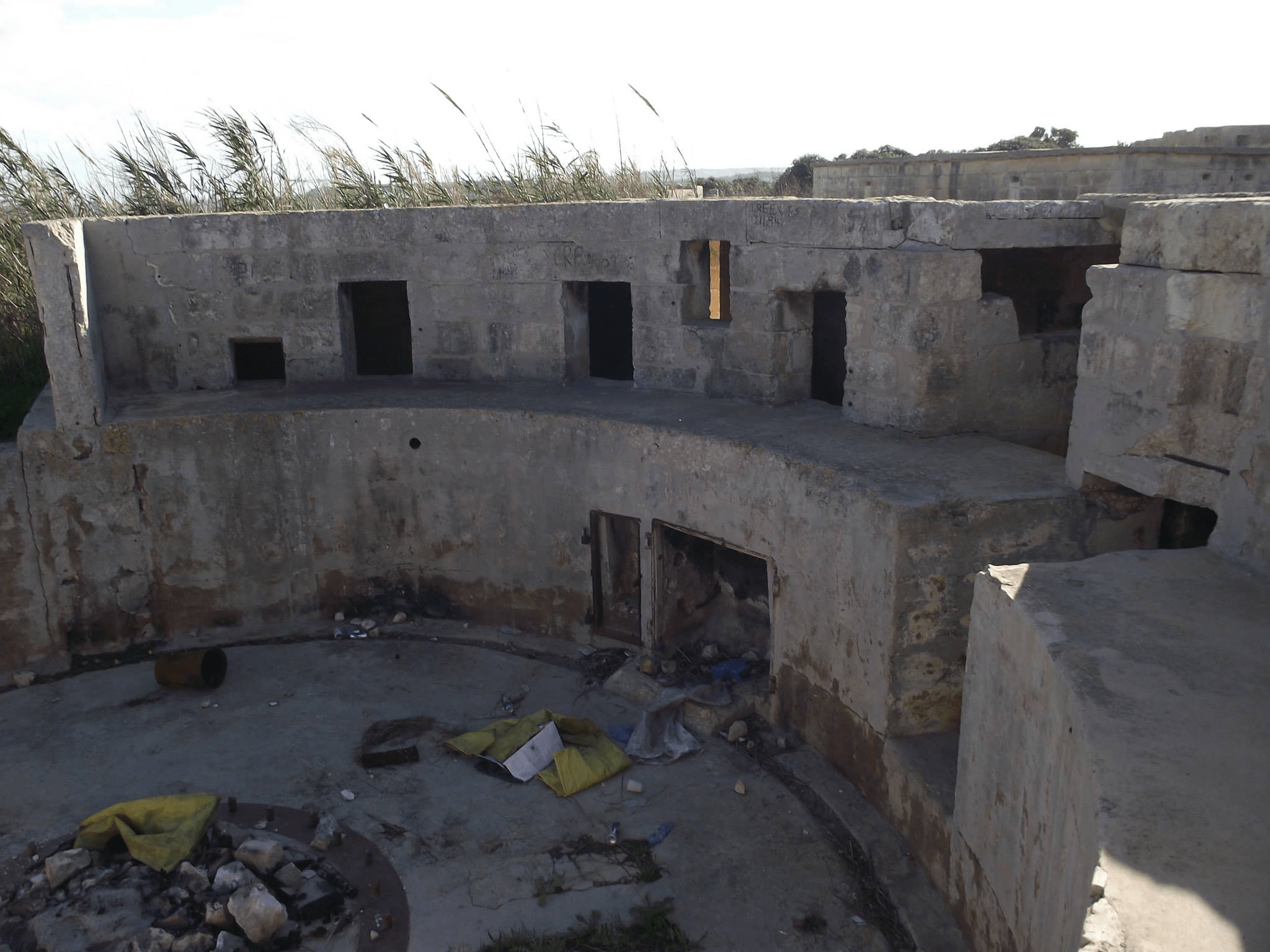
Internally, the fort’s buildings were all scattered in order not to create any concentration. 7 The buildings of the fort included the command post, gun emplacements, water tank, direction posts, barrack accommodation and magazines. Its most important structure was the Battery Observation Post (BOP), which was situated roughly in the middle of the area and faced north. 8
Fort Campbell had also Defence Electric Lights (Searchlights), which were situated a considerable distance away from the fort and situated along the shoreline to the north. There were three emplacements for searchlights, two of which were sited at the edge of the cliff overlooking the small island of St. Paul’s, while the third was placed closer down by the sea farther west. 9
References:
1 J. Manduca (ed)., The Bonham-Carter Diaries 1936-40: What the British Governor though of Malta and the Maltese, Malta, 2004, p 181.
2. Stephen C. Spiteri, The British Military Architecture in Malta, Malta, 1996, p 351
3. Manduca, p 225
4. E. Jablonski., A pictorial history of the World War II years, United States, 1977, p 19-20.
5. Manduca, p 225
6. Spiteri, p 351
7. Spiteri, p 353.
8. Spiteri, p 354.
9. Spiteri, p 357.
Researched and Written by: Charles Debono B.A.(Hons) History
The Transformation of Fort Campbell: From Ruin to National Park (2025–2026)
Following years of advocacy by the Mellieħa Local Council and heritage NGOs, the status of Fort Campbell has shifted from an abandoned military outpost to a primary pillar of Malta’s “Green” infrastructure strategy. In late 2025, Prime Minister Robert Abela announced that the fort, along with Manoel Island and White Rocks, would be reclaimed and restored for public use (Abela 2025).
Government Vision and the “National Park” Initiative
The current government plan focuses on a “balanced” approach between heritage preservation and public recreation. According to the Grand Harbour Regeneration Corporation (GHRC), which is overseeing several major fort rehabilitations, the goal for Fort Campbell is to create a high-standard open space that respects its unique “camouflage” architecture while providing families with a safe environment for leisure (GHRC 2026).
Key milestones in the project as of early 2026 include:
Public Consultation: A six-week public consultation period was launched in February 2026 to gather feedback on the “Vision Malta 2050” plan, which includes the fort’s regeneration (Attard 2026).
Student Design Workshops: In March 2026, architecture and engineering students participated in a three-day workshop at the fort, presenting design concepts to the Ministry for the Environment that emphasize the use of sustainable materials and the preservation of the original British-era footprint (The Malta Independent 2026).
Urgent Safety Concerns and the Ombudsman’s Ruling
Despite the grand vision for the future, the immediate state of the fort remains critical.
The Ombudsman’s report highlighted that current warning signs are insufficient to prevent the public from entering structurally “dilapidated and dangerous” buildings.
Collaborative Preservation
The government has indicated that it is in discussions with heritage NGOs, such as Din l-Art Ħelwa, to potentially involve them in the management and curation of the site once the structural restoration is complete. This reflects a broader shift toward “guardianship deeds,” where the state retains ownership while NGOs assist in the cultural and educational programming of historic fortifications (Newsbook 2026).
References (Harvard System)
Abela, R. (2025) ‘Prime Minister Announces Fort Campbell Will Be Another Open Space for Families’, Maltadaily.mt, 23 November.
Attard, D. (2026) ‘Major Grand Harbour regeneration plan opened to public consultation’, Newsbook, 5 February.
GHRC (2026) Prime Minister Presents Landmark Regeneration Plan for the Grand Harbour and Surrounding Forts.
Newsbook (2026) ‘Talks with NGOs to be part of park projects ongoing, PM says’, 22 February.
The Malta Independent (2026) ‘Students share vision for Fort Campbell’s transformation into national park’, 2 March.
The Shift News (2026) ‘Ombudsman vindicates Mellieħa local council’s complaint about dilapidated Fort Campbell’, 23 March.